Friday, December 24, 2010

El Sereno

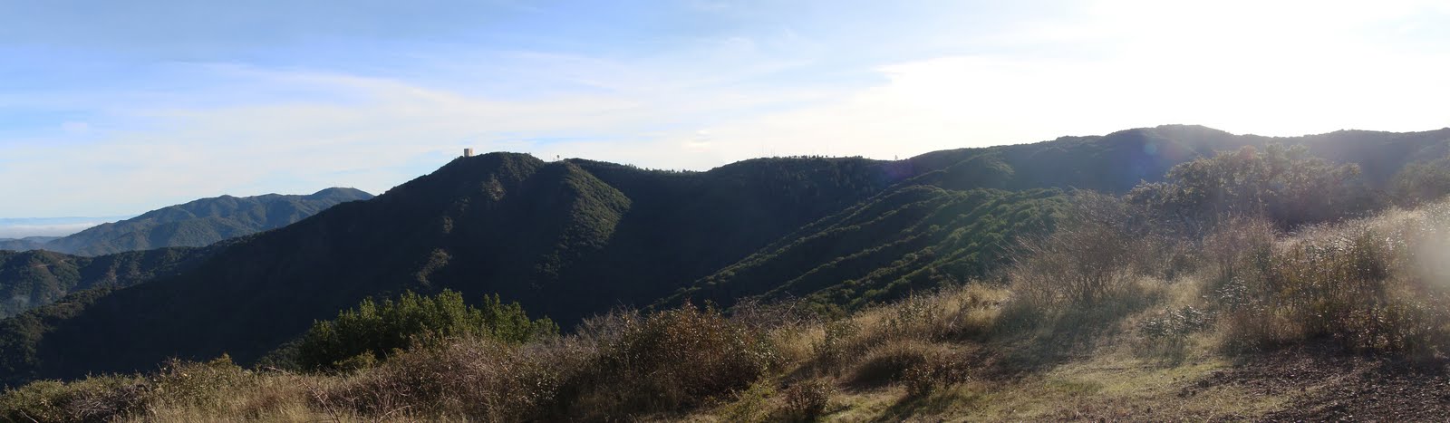
The week before Christmas was very rainy, so when I started my vacation yesterday I wanted to ride my bike, and needed to find somewhere that wasn't washed out.  I decided to head up El Sereno, the mountain just behind Los Gatos. It's an MROSD preserve, and therefore doesn't routinely close after rain, and besides much of the path is exposed and should dry quickly.

That's where I'm heading: El Sereno, as seen from Kennedy
The weather was clear and relatively warm, and after much dithering involving light coats and heavy shirts, I eventually decided that a normal T-shirt would be enough. Two days before Christmas, and I'm riding in a T-shirt.

Feeling full of oats as I set out, I headed for Los Gatos over the hilly Kennedy Road rather than the flatter Blossom Hill Road. I think a lot of bike riders avoid the flatter route because it has lots of traffic and no shoulder, but that doesn't bother me too much.

I don't recall the last time I crossed over Kennedy in this direction. Normally I'm either taking Blossom Hill to save my energy, or leaving the road midway to take the Kennedy Trail. For whatever reason, coming this way I noticed all the gigantic mansions (some, sadly, for sale) that start just after the crest of the hill.

Overlook Drive
Coasting into Los Gatos, I was reminded that it was actually a workday, and downtown was thick with traffic.  I passed through reasonably nimbly and started heading uphill on Pennsylvania Avenue and then Overlook. Overlook turns into a one-lane privately maintained road up here, hugging a ridge. What it overlooks turns out to be Almendra Creek.  After the recent rains, you could hear the creek running 100 feet below.

Switchback on Sheldon
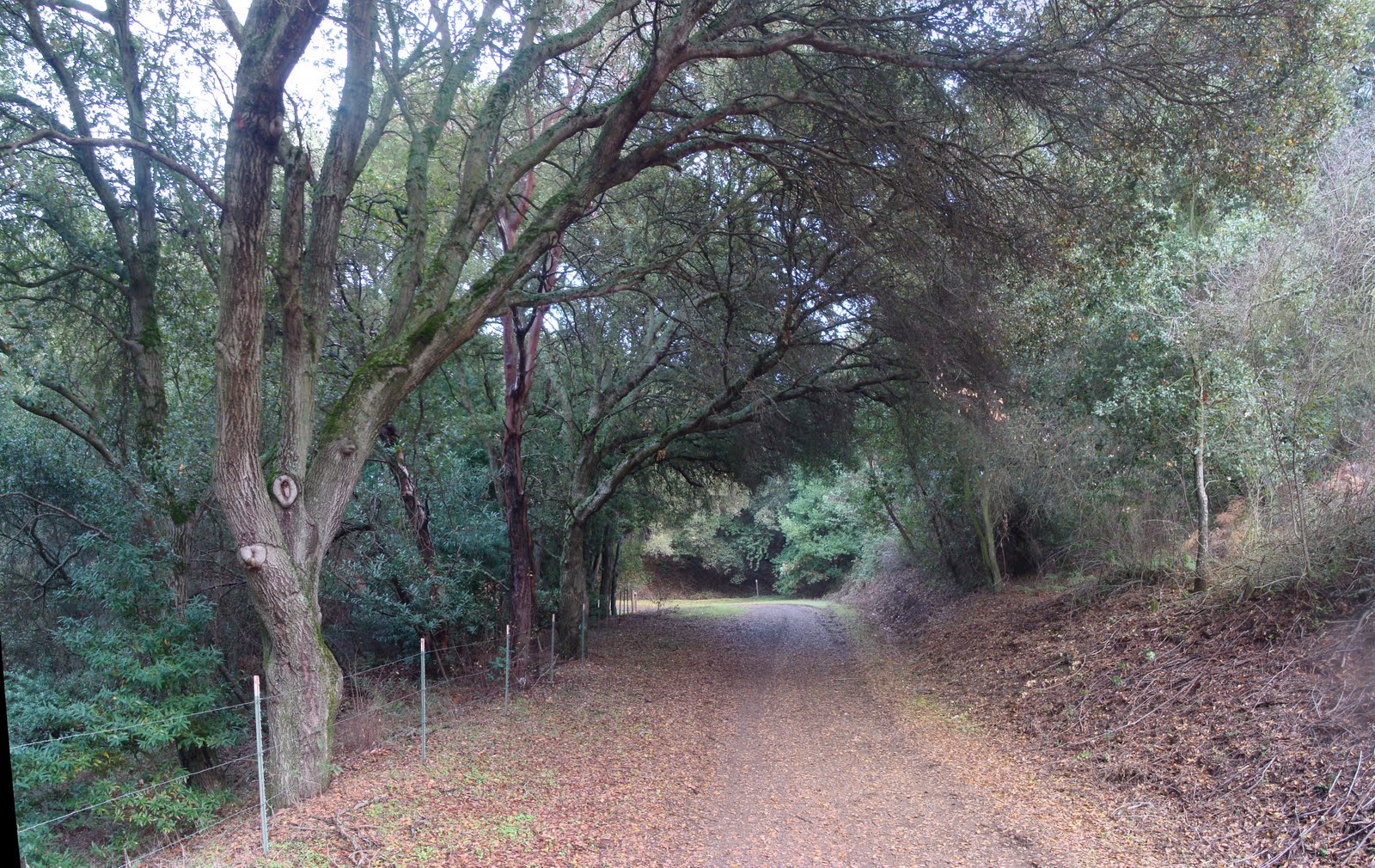
Overlook continues around the ridge, but to get to El Sereno you take Sheldon road, heading left up the ridge. Sheldon bends around for while and has several steep ramps. At the top of Sheldon (about 1200 feet elevation) is a gate to the preserve, and no parking. There's no parking on Overlook, either. I don't know how one would go about hiking El Sereno -- you'd have miles to walk just to get to it.

The trail that starts here is called the Aquinas trail. Even the covered parts were dry and firm, with only one or two spots of standing water and otherwise no mud.

Switchback on the Aquinas Trail in El Sereno
It starts out on the wooded northern face of a ridge for about a half mile, then rounds a corner and assumes its characteristic form: westward, exposed, with a view toward the south.  This valley is drained by something called Trout Creek, and is surrounded by this ridge on one side the ridge traversed by Montevina Road on the other.


The Aquinas Trail from Montevina,
with San Jose in the background
The trail occasionally peeks over the ridge for great views of the valley.  I could see Oakland and Mount Diablo to the north, the whole expanse of San Jose, the Santa Cruz mountains and even some fuzzy hints of Monterey.
The whole Santa Clara Valley, from El Sereno
I've ridden up El Sereno in the summer, baking in the sun and seeking out any available shade.  Today was quite the opposite.  Even with the strain of climbing, the T-shirt was a little too little for the weather, so the sun was welcome.

All in all, the trail climbs about 1200 feet in four miles, so it's not steep by any standard. The most challenging part for me is the mile just after the junction with the Serenity Trail, partly because it's slightly steeper and partly because it's late in the ride. The trail doesn't cross the actual peak of the mountain; it meanders around it. The top of the ride is the very definition of nondescript -- there's no crest, no sign, no trail junction, nothing to mark it. The trail up here is largely flat, so it's not even clear where the top might be.

The start (or end) of Montevina Road
Before you know it you run into the junction with the Montevina Ridge Trail, and realize the top's behind you somewhere. At this point you can head north, which takes you over to Bohlman, or south, which takes you to Montevina Road. The last time I did this I went down Bohlman, so this time I went down Montevina.

One last switchback, on Montevina Road
Montevina heads down the ridge toward the Lexington Reservoir, largely shaded by woods. I kept up a good speed on good pavement, but there was a surprising amount of traffic considering that there are only a handful of houses up here. At one point I found a little terrier walking up the road, but couldn't check its tags because it shied away. Meanwhile, a giant black SUV was heading down the hill toward us. I flagged it down, figuring it would need plenty of stopping distance, and might not notice the speck of a dog until too late. That tiny little animal, about the size, shape and intelligence of one of my shoes, stood in the middle of the road and barked at the SUV. That SUV never did pass me on the way down; maybe the dog never let it by.

Lexington Reservoir from Montevina
Montevina bottoms out at the highway and follows it south. At Bear Creek I crossed the highway, and found a problem. If you take a right here, heading south, you're on Old Santa Cruz Highway, headed for Summit Road. But taking a left dumps you on the highway; I had erroneously thought the road continued around the reservoir. Instead, there's a dirt trail. Normally that would be preferable, but after a week of rain it was muddy, and I really prefer not to leave ruts.  Well, there was nothing for it; I owe some trail work, I guess.

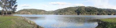
Water-level view of Lexington Reservoir
This time of year the water level is pretty low, and you can walk out pretty far on the shallow western edge. I would think that, when the reservoir is full, this area would be flooded. But would those trees survive that? Maybe the level's not so low after all.

The trail ends on Alma Bridge Road, where my tires emptied their mud onto my shirt. I followed this road across the dam and onto the Jones Trail. "Buffalo" Jones arrived before the gold rush, and disappeared shortly afterward. In between, he operated Jones' Road, one of the first roads linking Santa Cruz with the Santa Clara valley, possibly as a toll road. He claimed to have built it, but it may have followed an old Spanish mission road. In any case, in this area it was so steep that full wagons couldn't pass -- they had to partly unload at the bottom and make two trips. I was reminded of this as I climbed the preposterously steep opening ramp of the trail. I'm not sure it's the same path, but if it is, you can see why they looked for alternatives. Near the top of the trail you can see the ultimate alternative, the highway, some 300 feet below. It looks almost straight down from there.

After this it was an uneventful trip back over Blossom Hill (this time on a busy Blossom Hill Road around rush hour). About 30 miles in total, and the computer reports 3600 feet of climbing. That may not be too far off, since I did some extra climbing around Kennedy.

Sunday, December 12, 2010

Kennedy Trail and El Sombroso

Sometimes I ride to explore new areas, but other times I just ride.  Yesterday was one of those other times.  The weather report showed a nice sunny day, and I decided to ride up the Kennedy Trail to El Sombroso.  I've done that ride before, and was wondering whether I might be showing any improvement of form.


It had rained overnight, and was quite foggy when I left in the not-too-early morning.  I expected the fog to burn off before I climbed up to it.  I brought a coat, but before I had even started climbing I was comfortably riding in my T-shirt.

Getting to the trailhead from my house is a good warm up, since you have to climb Kennedy Road up to about 800 feet.  The first part of the trail is flat and was worrisomely muddy.  I don't like leaving tracks let alone ruts, so I was glad to see that the trail was firmer once it turned upward.

The Kennedy Trail up to the junction with the Priest Rock trail is about 4 miles long and climbs about 1800 feet, for an average grade of about 8.5%.  But that's a little deceptive because there's a drop near the start of the climb and a false top near the end.  In between, the trail climbs 1600 feet in about 2.7 miles, for a grade over 11%.  That may not sound like much, but when you're lugging as much weight as I am, it's huge.

The early part of Kennedy Trail, cruelly dropping

In some sections, the trail was muddy enough to stick to the tires, and my traction wasn't great.  I mention that only to say that everything else was perfect -- cool but not cold, some fellow riders but not too many, breezes but no wind.  Couldn't ask for better.

The oak in Kennedy Trail, in fog
(plus exposure matching problems in the mosaic)
In the middle of the ride is a flat section with a huge oak tree right in the middle of the trail.  On hot summer days this is a great place to recover.  Most weekend days, you'll probably even get a little company here, so you can commiserate in your suffering.

On this cool winter day, the fog was sitting at this level, so it was an even better place to spend a little time.

A lovely view of San Jose from the Kennedy Trail.  Or maybe not.

Shortly after the tree, a few hundred feet higher, the fog had thickened.  No views of the valley at all.  One of the little rewards for climbing a hill is the view at the top.  I was hoping this stuff would burn off, but it was already midday and it looked like the fog was winning the battle. 

One nice effect of the fog was that it masked the length of the climbs in this section -- you couldn't see the top and get dispirited.  I'm not sure the ramps in this section are really steeper than those lower down, but after all that climbing they seem so.

As I reached the junction with the Priest Rock trail, I had finally climbed out of the fog into crystal clarity.  The fog sat thick across the whole valley, leaving just the surrounding hills in view.

Los Gatos and El Sereno, from the Kennedy Trail
I've climbed up the Kennedy Trail to this point several times, and I'm justifiably proud that I can do it.  There can't be many people who could accomplish such a feat, right?  Well, let me introduce you to the annual Kennedy Trail turkey ride.  Early Thanksgiving morning, a bunch of riders climbs up Kennedy and traditionally enjoys a little snack at the top.  A bunch of riders?  The most recent ride attracted hundreds -- one estimate put it at 2000.  Young people, old people, men, women, kids.  I complain about carrying my fat keister up the hill, but people tow kid trailers up there.  At least one guy towed a cooler.  It gives one perspective.

A terrible ramp on the Kennedy Trail,
heading toward El Sombroso.
There was a couple at this junction deciding whether to head down to Lexington, or continue on toward El Sombroso, which they hadn't done before.  I described the trail.  The fact is, I don't much like this next section.  It has a couple of ramps that I had to walk up on this ride, and at least one long hill that I'll never climb.  I hate pushing the bike.  Plus it's up-and-down, so you can't even surrender -- there are climbs either way, so you're trapped.

The couple decided to try it.  In the picture here, if you zoom in, you can see one of them nearly clearing the hill I'll never clear.  On his first try.  Sigh.  To be fair, he had described coming up the Priest Rock trail as not particularly difficult, so he may be superman.

The first time I rode this route it was summer, and I had emptied my water bottles by the middle of this section.  The sun was high and I was broiling, stopping in the shade of every shrub just to keep my temperature down.  As I was feeling sorry for myself, along comes a runner.  At least 5 miles and 1800 feet from civilization, this guy is running the trail.  He's got to be 70, and is carrying no water.  He mentioned finding water further along the trail, and I had to break it to him that there's none to be had on any of these trails.  He patiently explained to me that he was talking about water from one of the many streams up here.  I aspire to that level of resourcefulness.

Eventually the trail gives up the up-and-down indecisiveness and settles on "up", very near the junction with the Limekiln trail.  The trail here parallels the power lines, which cross right over the top of El Sombroso.  Or as near the top as you'll get without some serious bushwacking, anyway.  There's a little spur trail up here, presumably built to service the power lines, that's constitutes the top of this ride at just short of 3000 feet.  From this less than bucolic spot you have good views of Umunhum and the Rincon Creek watershed, but no view of San Jose.  To see that, you'd have to get to the true peak, which is protected by forbidding scrub.

The Umunhum/Thayer ridge, from El Sombroso.
Mt. Umunhum Road is in the lower left, and the Sombroso/Thayer
ridge is on the right-hand side
The trail, which by this point is called the Woods Trail, continues counter-clockwise around the peak and heads down.  Actually, at this point there are only two brief uphill sections on the entire trail down to Hicks Road: one right away, near the peak, and the other at the very end.  Neither is steep at all, but tired legs feel every rise.

I've only ever ridden down this trail, never up.  It seems impossibly steep, and if that's not tough enough it's loose and rocky, too.  But people do ride up it, including a pair of riders I briefly talked to on this ride.  I must try that someday.

The trail isn't too bad, but it has the quality that a mistake on the descent could send you over a cliff.  So I tend to take it pretty darned slow.

The Umunhum "monolith", from the Woods Trail
It's on this part of the trail that you get the best views of the box on Umunhum.  The mountain is incredibly steep from this perspective.  Apparently you can climb Umunhum along one of the ridges, but not from this direction.  The preferred route starts on Barlow Road, but apparently there's an overgrown trail on the ridge from El Sombroso, too.  I looked for that latter trail as I passed; it's completely hidden from Woods Trail, and hiking reports say it's not really passable.  But it shows up clearly on satellite images, which tells you how misleading those enhanced images can be.

After the initial steep drop from El Sombroso to about 1800 feet, the Woods Trail heads generally downward at a gentle slope, past Barlow Road and toward Hicks.

The Woods Trail
According to a historical sign in Quicksilver park, the Woods Trail was once the Wood Road, built to feed wagonloads of wood into the mercury furnaces in the mines here.  Considering the years the furnaces operated and their appetite for wood, these hills must have been stripped bare.

I went down the north side of Hicks, which was uneventful except for a slippery patch of mud right at the U-turn that defines the bottom of that very steep hill.  I would have expected to see a pile of mangled road bikes off the side of the road, but happily there were none.

Quicksilver Park, from Hicks
The Guadalupe Reservoir certainly looked low. I suppose it hasn't had the chance to recharge yet, but the stream filling it is a trickle.

A good ride for me, and considering how exhausting it was, surprisingly short.  Just 24 miles or so, and the computer reports about 3700 feet of climbing.  It was probably closer to 3400, since I also explored some unfamiliar hilly roads on the way home. A good ride, but I'll need to be a lot stronger before I consider towing a cooler behind me.

Monday, December 6, 2010

Herbert Creek, Again

Last time I rode my bike up the Herbert Creek trail, I took a wrong turn and didn't get very far.  So I decided to try again.  Today would be about exploring all those spurs that I had spurned earlier.  And again, I didn't get very far.

Almaden Reservoir, with the Loma Prieta ridge in the background
The weather report has called for rain for days, but very little has appeared.  Lots of wind today, but little rain.  As I passed by Almaden Reservoir I had my raincoat in my bag, and was comfortable in my T-shirt.

Twin Creeks.  Well, one of 'em, anyway.
After Alamitos Road passes Hicks, it gradually becomes enclosed by woods.  The road steadily decreases in width from two lanes as it enters Twin Creeks to barely one lane (but still paved) as it heads up the river.

As I passed through, Twin Creeks was quiet.
The fork in Herbert Creek trail
At the fork in the road, I took the high road, the one I skipped in my earlier trip.  As you can see, the gate was open, almost inviting me in.  But that welcome didn't last long.  Perhaps 100 yards after this junction, I could see a set of cars parked all over the road.  Well, not cars -- trucks.  White trucks.  White pickup trucks are the standard vehicle around here, more numerous than people.

In this part of the world it wouldn't be unusual to see abandoned vehicles, but these trucks were obviously still shiny, and indeed there were people milling about. If I wanted to continue, I'd have to ride through, and I wasn't about to do that.

So the Herbert Creek trail, for which I had high hopes, didn't have much to offer.  I knew that the other trail ran into buildings after a few hundred yards.  But not having anywhere else to go, I headed in that direction.

Herbert Creek Trail
The trail was damp but not wet.  This area probably doesn't get too dry even in the summer, considering the moss on the trees.

A little ways up the road, there's a branch covering about 2/3 of the trail.  I remember seeing it there last week.  There's not enough room for a car to pass, so apparently no car has passed this part of the road in a week.  A motorcycle could make it, I guess.

When I got to the buildings I really did mean to pass through, but... well, they looked pretty well kept, and there were a lot of them.  They couldn't possibly be abandoned.

Just short of the buildings, there's a spur of trail that crosses the creek and heads up a ridge.  So having balked at the buildings, I tried that route.  Within a few feet it became clear that the trail had not seen recent maintenance, and that its grade meant it was a hiking trail, far too steep for a bike (or a bike ridden by me, in any case).  It headed southwest, diagonally up the ridge.  If it continues, it must reach the Loma Prieta ridge (after looking at some maps, this trail may just go up a ways to a barn, not all the way up to the ridge).  I was surprised to see that my Garmin device completely ignored this little side trip; I guess my hiking pace didn't register at all.

Eventually I gave up on that and headed back to the main trail.  Near the same position, another spur leaves the trail to the left, climbing up the opposite ridge.  I headed up that trail, but it comes very close to some mobile homes that are part of this little complex of buildings.  So I pretty quickly turned away from that, as well.

One last thing to check before I called it a ride.  On some maps, the trail that heads from the Twin Creeks area to the Loma Prieta ridge has a spur that reaches this Herbert Creek trail.  I think I found that connection, which takes the form of an overgrown trail, blocked from the main trail by a chain and several tree stumps.  So that seems to match up, but again this is a trail for hiking, not riding, so I wasn't going to be exploring that today.

All in all, very little new riding trail uncovered in this ride, although of course I found plenty of hiking trails.  I got up to about 1100 feet at the top, which was near the buildings.