Saturday, September 29, 2012

Mount Hamilton

Last Saturday I set out to ride the Hamilton/Livermore loop, but ultimately only did the first part.


View Mount Hamilton in a larger map

I drove to the Berryessa community center reasonably early, and set off on the bike just after 9 AM. It was a lovely day, and I headed down White Road to McKee, then Alum Rock Avenue, then up Mount Hamilton Road.

By the time I was getting to the flat and open part of the first climb, it was already warm. On the second climb it was getting pretty hot, and considering that I was planning a 100-mile ride, I was already feeling uncomfortable in the saddle.

On the upper part of the climb I had nearly finished my two water bottles, which wasn't a good sign; it wasn't even noon yet, and would it would be getting a lot hotter in the dry valleys behind the mountain. The fact that I had finished two bottles meant that, try as I might, I'd be completely dehydrated at the end of the ride. So I punted; I'll do the loop when it gets a little cooler.

From the Lick Observatory, looking north.
This was taken with the new iOS 6 panorama mode.
On the way down I enjoyed the newly repaved road on the last hill. It's now quite smooth, and those two bone-jarring ruts midway down are gone. The other parts of the road that were gravelly a few weeks ago are now solid, although much rougher than that smooth top section.

Elevation profile
This ride was just 44 miles, less than half of what it should have been, with 4900 feet of climbing. The most difficult kilometer was midway through the top climb at 6.2%, just slightly steeper than the average of 5.9%.

Monday, September 17, 2012

Big Basin

On Sunday I took a long bike ride through Big Basin Redwoods State Park.


View Big Basin in a larger map

Like most days around here, the morning was chilly but the afternoon would be quite warm. I didn't want to bring any cold weather gear, so I dawdled a bit, waiting for the sun to assert itself. At about 9:30, I set out.

I've done this route several times, but it's been a while. It's one of my favorite rides, partly because it passes through one of the prettiest parks in the area and partly because the length and climbing are a good challenge for me.

I took the familiar route down the Los Gatos Creek Trail, this time having to walk my bike up the steep section because I spun out in the dust. I think that section becomes dustier and more difficult as the dry season wears on, and we're nearing the end of that cycle. I hope so, anyway, because I'm starting to loath that ramp, going up or down, but it's the only way through.

Old Santa Cruz Highway
Old Santa Cruz Highway took me up to Mountain Charlie Road, which I slowly climbed to Highway 17, and across to Summit. I descended Bear Creek Road nice and fast into Boulder Creek, where I had my customary lunch at Foster's Freeze. The owner surprised me by asking if I knew "Jobst". I don't, but as an older cyclist in the Santa Cruz mountains, it was a fair bet that I would know Jobst Brandt by reputation. Or perhaps by legend. The owner lamented Jobst's absence, both from the Foster's Freeze and as a familiar sight riding through Boulder Creek. Yeah, me too.

After lunch I slowly set off, up Route 236 toward Big Basin. There's a bit of a hill in between Boulder Creek and the park, so when I enter the park I'm normally coasting down the hill. Coasting down a quiet road, on a warm day but in the cool shade of giant redwoods... this is basically why I ride the bike. I'm very lucky to be able to do this.

North Escape Road
At the park HQ I filled up my bottles, then headed up North Escape Road. Initially this road passes through additional parking lots and picnic areas, and folks walk along the road. A little later, I saw a troop of kids on a hike. But after that, I had the whole road to myself.

North Escape Road is largely flat until it crosses a creek, at which point it's pretty steep. In fact, the most difficult kilometer of the ride was in this section, with an average grade of a little over 10%. The lush setting, including a road covered with a soft bed of pine needles, somehow makes that grade much more enjoyable than similar climbs on sun-drenched roads. In fact, North Escape Road ends back at Route 236, which then becomes one of those shadeless roads for a mile or so.

I followed Route 236 to its junction with Highway 9, which I climbed to Saratoga Gap. After a pleasantly fast descent into Saratoga, I took the normal route over Kennedy back home.

Elevation profile
This ride was just short of 72 miles, with 6600 feet of climbing. It's a big ride for me, and I was pretty sore at the end of it. I think part of that is just because it was warm, and consequently dehydrating. Still, it's a great way to spend a day.

Thursday, September 13, 2012

Shoreline

I've always admired people who manage to organize their lives such that they can commute by bike. On Tuesday I decided to pretend to be one of them, taking a pleasant (but flat) ride in the morning traffic.


View Mountain View in a larger map

... but not exactly early morning traffic. After my morning errands, I only hit the road around 9, after the peak of the rush hour. I was heading up to Mountain View, so I started on Camden and the San Tomas Expressway. Normally my rides are focused on climbs, so this was one of the few times when I could really try to ride quickly on a flat road. I was surprised to be able to maintain 20 mph or more reasonably easily, although it's apparently slightly downhill in this direction so I shouldn't get too excited.

Bone dry wetlands in Sunnyvale Baylands Park
I didn't really have a path in mind. When I got to Monroe, I thought the San Tomas Expressway was going to peel off eastward soon, so I took a left. Almost immediately I came upon the San Tomas/Aquino Creek Trail, and decided to see where that went. As it turns out, it goes quite near the bay, crossing 237 up toward Alviso. At that point I headed west through Sunnyvale Baylands Park, stopping briefly to look out at... well, not much, really.

After that I continued around Caribbean Drive, past the Yahoo! headquarters, and then took Moffet Park drive past the airfield on the way to Middlefield Road. I continued west to Shoreline, then took that up to, and around, the Google Headquarters.

I took Rengstorff south until it ends at El Camino Real, then took Springer south through Los Altos to the Foothill Expressway. Then I took that around to Stevens Creek, Blaney, Bollinger and then back on San Tomas Expressway and home.

Elevation profile, with especially exaggerated elevations.

This ride was a little under 50 miles and basically flat, with just 700 feet of climbing. But it shows that in a commuting scenario I can maintain a decent speed, which may just come in handy in the next few months.

Monday, September 10, 2012

Umunhum and Metcalf Road

Saturday I took a short bike ride around some pretty steep hills in the area.


View Umunhum and Metcalf in a larger map

My bike's rear tire was flat, which conspired with normal morning stuff to get me out a little late. As it turns out, the hole was on the bottom side, so I suspect that I must have pinched it last time I changed the tire. I've been riding on Serfas Seca 25 mm tires since just before I went to France. That was perhaps 700 miles ago. The back tire was worn quite flat, but worse yet had lots of cracks and cuts and whatnot. I swapped it for the 23 mm Ritchie slick that had previously been on the front, and was still noticeably round. I set out at 10 AM, hoping that I hadn't pinched this tube, too.

The currently-legal top of Umunhum, the highest point you can legitimately go, happens to be almost exactly 10 miles from my front door. I headed that way, passing from noisy suburbia to the very quiet, isolated Hicks road. Six miles into the ride I crossed the bridge that marks the start of the climb up Hicks.

The first time I rode up Hicks on my road bike, I weaved all over the road. When another rider passed by, offering encouragement, I remember saying that while I was familiar with the climb, I had only previously done it with mountain bike gears. I guess I must be a little stronger now, since I don't weave (much) anymore. Still, it's a slow and difficult climb for me.

This time I saw no other riders, either on Hicks or after I had turned up Mount Umunhum Road. This road always seems manageable because although it is very steep, it's not as steep as Hicks. I got up to the top in good order, and ate a Clif bar near the little forest of signs at the top. Then I made my way slowly and carefully down, dodging potholes and patches and gravel on this awful road. I took Hicks road south, toward New Almaden.

Normally on a ride like this I just head back home, for a quick 25-mile trip. This time I wanted a little more, so at Harry Road I took McKean south to the Calero reservoir, then took Bailey Road over the hills. I had ridden on this section of Bailey Road a long time ago, shortly after I moved to this area, and I knew there was a climb before the descent into the Santa Teresa Valley. But my memory was playing tricks on me; there's practically no climb from this direction, although there's a good descent on the other side.

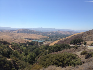
Looking back at Santa Teresa Valley
from Metcalf Road
When I got near the IBM facility, I looked at a map to think about where I ought to go. One glance showed that Bailey heads west to the base of Metcalf, which was basically perfect. I hadn't done enough climbing today, so Metcalf would help. The problem was that I was nearly out of water; on the ride so far, there is zero water.

I climbed up Metcalf with creaking knees, wondering what I had got myself into. On the way up I was thinking that the motorcycle park must have water available, and when I got there I found not only a fountain but three vending machines. I enjoyed a "sports drink" before heading down the other side of the mountain.

Along San Felipe Road
The only other time I came up this way, I ended up going to the end of San Felipe Road, then returned back the way I came, over Metcalf. This time I took a left on San Felipe Road and descended into San Jose. Well, first I actually had to climb a little, which was rough on my now-tired legs. Then it was a quick descent toward San Jose.

I took Farnsworth Drive over to Silver Creek Valley Road, a little disappointed to find that I still had a bit of climbing to get to the top of the hill. Silver Creek Valley Road is wide, with two wide lanes in each direction, plus generous bike lanes. It's pretty steep and straight and doesn't get much traffic, so on the descents you can really get some speed. In my case I got to 45 mph heading down the west side of the road, taking up the right lane because the dusty bike lane's not quite enough at that kind of speed.

After that it was a quick trip home on Blossom Hill Road.

Elevation profile
This was a relatively short ride, coming in at 49 miles and 4800 feet of climbing. But pretty stiff climbing, I must say; both the Umunhum and Metcalf climbs average a 10% grade. The most difficult kilometer was near the bottom of Hicks, where it averaged over 14%. Not bad for a short ride.

Sunday, September 2, 2012

Mount Hamilton, both sides

Yesterday I got back on the bike for a long ride over Mount Hamilton to The Junction for lunch, then back again.


View Mount Hamilton, both sides in a larger map

In June I tried this same ride, but stupidly did it on a Monday, when the damned restaurant's closed (except tomorrow, a holiday). I must say it's a much more enjoyable ride with a nice meal in the middle of it.

I got a late start, setting off from Alum Rock Road at 10 AM. Although the parking lot was full, I didn't see many riders on the road. Not much to report on the way up, except that they're repaving the road around Grant Park, so there's a lot of loose gravel. Nearer the top, there has apparently been a small recent fire, which is certainly awful and to be avoided, but which has left a really pleasant scent.

San Antonio Valley Road, climbing
back toward Mount Hamilton
After a little rest and fruit juice at the observatory, I headed down the east side of Mount Hamilton into the isolated valleys beyond. This late in the season, the valley is bone dry. Even the cattle, numerous in my previous trips through here, were scarce.

I found my way to the bar, just about the only speck of civilization between Mount Hamilton and Livermore, at a little after 2 PM. I had a BLT (the B was great, the L was fine, but the T were underripe) and various drinks, then headed back the way I came. It was only at this point that I saw any other riders on this road, when the passed headed toward The Junction.

The rolling hills on the way to Mount Hamilton are steeper in this direction, and since by now it was the hottest part of the day, it seemed even harder. As I got nearer the mountain, however, the shade grew deeper, and I could watch the thermometer on my computer drop from about 95 down to 85 as I began the long climb back up toward the observatory.

The Mount Hamilton trickle
Almost exactly halfway up the climb is a spring, one that was especially welcome on my last trip. This spring is very similar to the fountains in the middle of all the french villages, with water flowing into a small pool, presumably for animals. This late in the dry season, the flow was down to a trickle, but I stocked up nonetheless.

By the time I got to the top I was exhausted. My legs were sore and shaky, and my back was troubled by the relatively steep sections. Partly due to that, and partly because the day was getting a little chilly (the computer was reading 70 degrees), I passed by the observatory and just headed straight down.

This late in the day there were very few cars on the road, so I made good time. The new gravel makes for flat roads, but I don't really trust them, so I took my time on those. When I finally got back to smooth roads after Grant Park, I gratefully let loose again.

Elevation profile
Since I've been riding less often lately, this was a big ride for me. It ended up just short of 75 miles, with 8200 feet of climbing. The hardest kilometer was right in the middle of the backside of Hamilton, with an average grade of 9.6%.