Last week, I learned the lesson that when they close the road to Mount Hamilton, they close it for bikes, too. So this weekend, with the same goal of just seeing some stinking snow, I decided I'd ride up the nearest big hill: Mount Umunhum. Umunhum got some snow last week, and it tops out at close to 3400 feet, so surely it would be pleasantly snowy, right?
Well, boo hoo. I was left with a lovely cool-but-not-cold day in late February on which to have a nice long ride. I put on two T-shirts and a windbreaker and set off for Umunhum on my mountain bike.
Umunhum is notable because of the huge cubic monolith on its peak. You can see it from all over the valley, and that incongruous and literally unnatural bit at the top stands out like a pimple. As it turns out, the cube is a six-storey concrete support for a long-gone radar dish. It is among the remains of an Air Force station that looked for Soviet ICBMs from 1957 until 1980. When I first moved to the valley, rather close to the mountain, I made it a goal to one day, somehow, ride my bike up there. It took me a few tries, but eventually I made it (as far as one can reasonably go; more about that below), and I've ridden up a number of times since then.
To go up Umunhum, you first ride up Hicks. In my case, I was riding from the north, from Camden. Hicks runs next to Guadalupe Creek and climbs gradually, but you hit a notable hill climbing up to the Guadalupe Reservoir. The hill is steep, but probably climbs less than 200 feet. Whenever I'm climbing it, it's hard not to think that if I find this little hill difficult, how am I supposed to deal with the remaining 2500 feet?
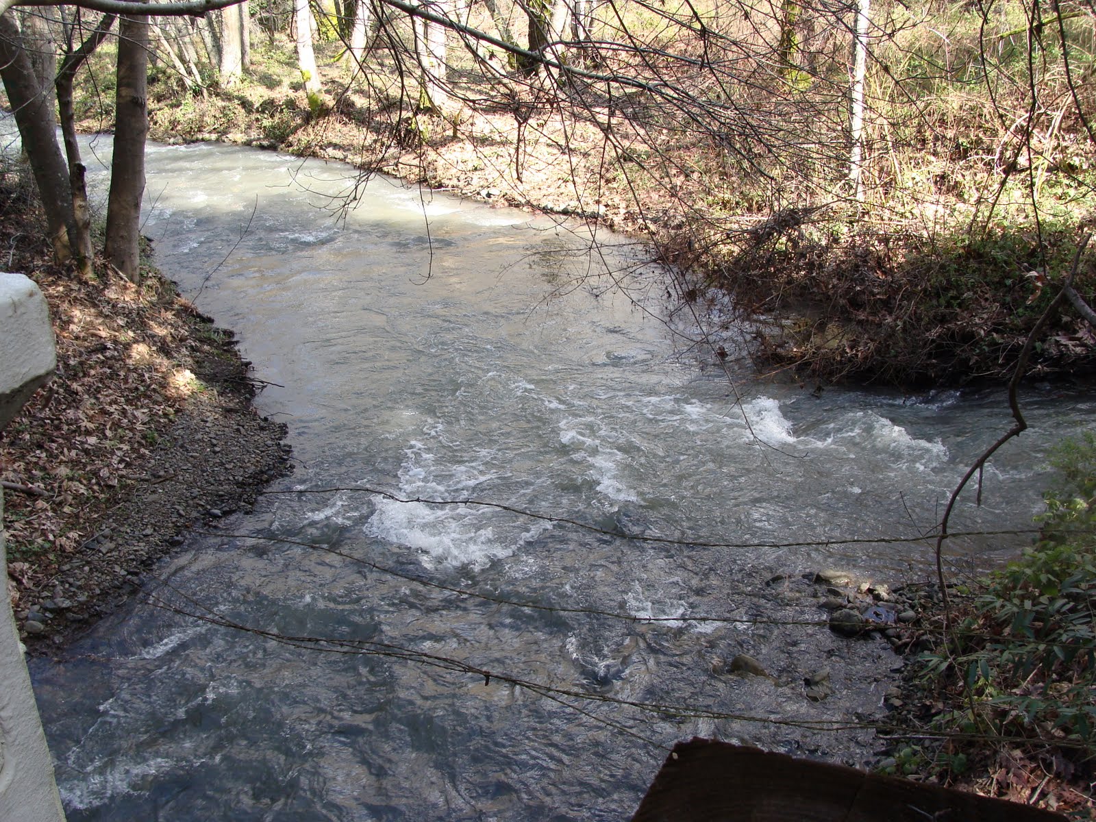 |
| The confluence of the mighty Rincon and Guadalupe creeks |
The reservoir is a local high spot, and the road generally falls toward a pair of bridges where the Rincon and Guadalupe creeks meet. On this day, both were flowing heavily. The road here makes a sharp turn, which marks the start of the climb. From this spot, Hicks is quite steep all the way up to the intersection with Umunhum.
The last time I rode up Hicks I was on my road bike, and I struggled. This time, given the cool temperatures and the low gears of the mountain bike, I didn't have too much trouble. To put that in perspective, I still ended up zig-zagging across the road occasionally, but didn't feel the need to stop and catch my breath.
Hicks tops out (at about 1400 feet) at the intersection with Mount Umunhum Road, where there's a little parking lot serving the Woods Road trailhead. On this beautiful day the lot was nearly full. Here's a tip: if you ever find this lot full, there's a large parking lot across Hicks in Quicksilver park. It's a little walk, but then that's the point, right?
 |
| Umunhum Road needs a little love |
At this point I ate one of my horrible little food pellets (made slightly less horrible because it was a chocolate chip Clif bar) and pulled off my windbreaker. Then back on the bike and up the crumbling road.
A little more history is in order. The Lick Observatory on Mount Hamilton was constructed in the 1870s. The materials had to be hauled up the mountain by mules, so the road couldn't be too steep. The Almaden Air Force Station, by contrast, was built in the 1950s, and diesel trucks don't complain as much. The Umunhum road could therefore be steeper, and steeper means cheaper. Actually it's not quite was steep as the north side of Hicks, but it's still pretty steep.
On this lovely cool day, the climb was hard but not exhausting, and I made my very slow way up without stopping. Except for pictures. No, really, just for pictures!
 |
| One of the signs warning about lots of construction work going on. This one was near the top. |
Near the start of climb, there were signs indicating that since clean-up work was starting on January 24, 2011, that there would be an increase in truck traffic. Maybe there would be some visible change near the top? Answer: no, no sign of any work, except of course those, er, signs.
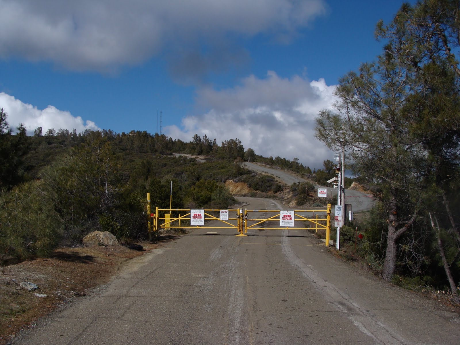
Midway up the mountain (about 2300 feet) is a gate that marks the end of the line for cars. Well, most cars -- residents, rangers and operators of the communication equipment on the top of the mountain can pass. As I took a moment at the gate to eat another half of a food pellet, a resident (I suppose) came down. I asked about snow the previous night, and got a shrug in response.
There's a section shortly after the gate, starting roughly at the intersection with Barlow Road, where the road is especially steep and almost entirely exposed to the sun. I would guess that it runs about 5 miles, but somehow on the map it's only about 500 meters. I have many memories of riding up this thing on warm days, my head threatening to explode in the heat, collapsing in the scant shade of each of the lonely trees on the side of the road. This time, not so bad. A cool day and perhaps slightly better conditioning, and it's only steep, not miserable.
After that ramp the grade moderates and the road curves around a bit. Among the curves, you run across the first of several signs indicating that you must not, under any circumstances, proceed any farther. This is reinforced by the existence of a creepy (under the circumstances) collection of mobile homes and trucks and tents and whatnot off the side of the road. The first time I saw these signs, I turned around. The next time, and every time since, I rode right by. My justification for doing so is approximately this: the views near the top are spectacular. One could argue that the road is a public easement, regardless of whether it crosses private land and whether one has valid business beyond it. But the real reason is because it's there.
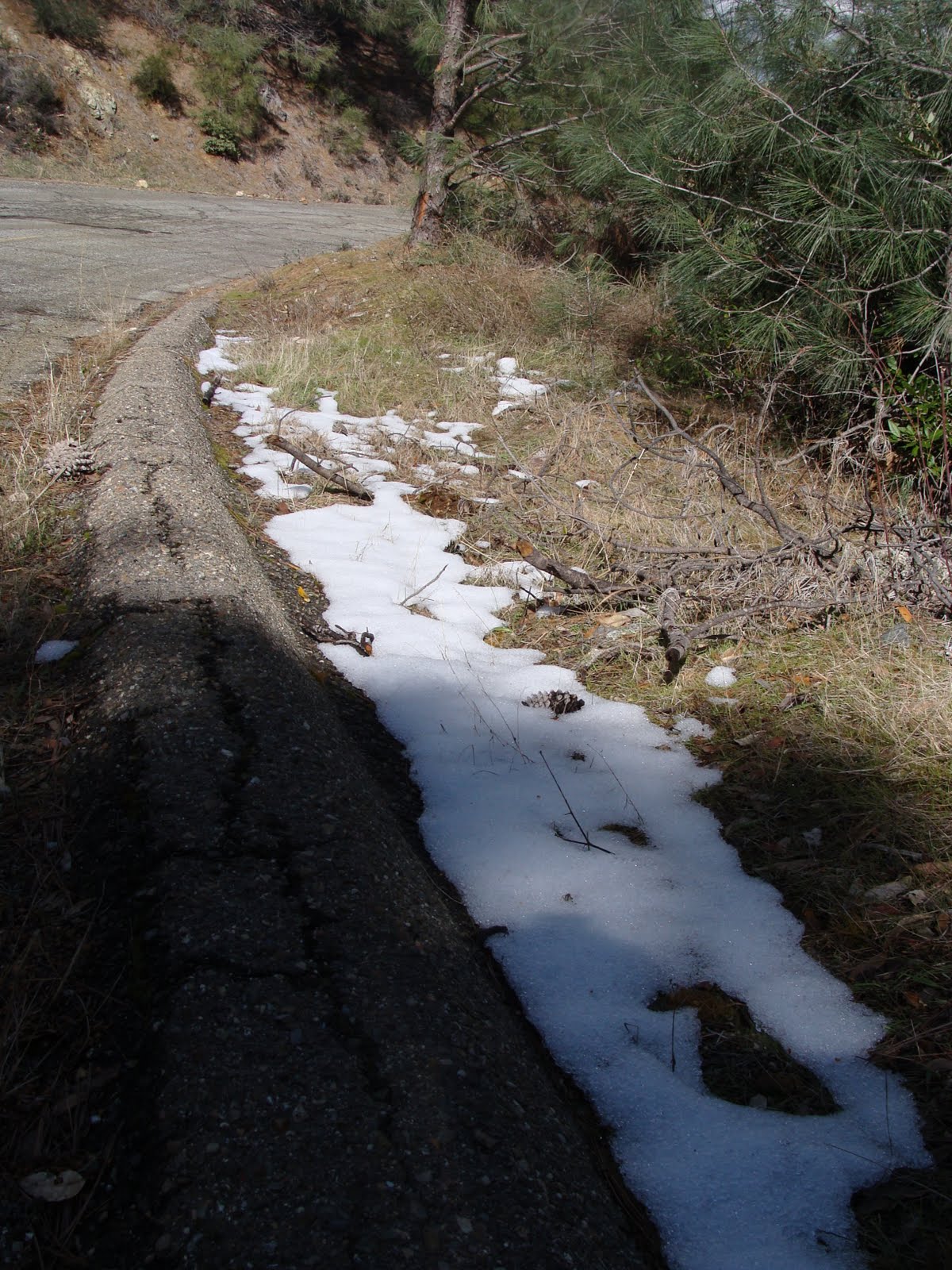 |
| Bona fide snow, at the 3000 foot level of Umunhum Road |
 |
| The end of Umunhum Road |
The section past the signs runs up the eastern side of a ridge, and is surprisingly long,. Eventually it crosses over, at about 3300 feet. At this point, Umunhum Road turns to follow the other (western) side of the ridge, and two dirt tracks head south on either side of it. Umunhum Road continues for a few hundred meters until it meets a gate, which is where I stop. My bogus justifications for coming up this far probably apply to the portion beyond the gate equally well, but so far I've never crossed it.
 |
| View from the gate on Umunhum. Mount Thayer is the tallest point, in shadow. On the ridge are radio towers and the Air Force Station. |
Near the gate you are rewarded with expansive views toward the south and west. The foreground is a steep drop into Austrian Gulch and Lake Elsman. The middle ground is the Summit Road area, and in the background are specks of Santa Cruz and Monterey Bay. Toward the west you can clearly see the serpentine trail heading up Ralph's Mountain, and the ridge leading to Mount Thayer. As that ridge turns toward Umunhum you can see the communication towers and the sad ghost town that was once the Air Force station.
The fact that the view faces south, and I'm normally here in the afternoon, means that I'm always taking pictures into the sun. If I were a better photographer I'm sure I could capture more of what you can actually see. For example, the bay was dim but quite visible, whereas in my shots you really have to zoom in to see it at all.
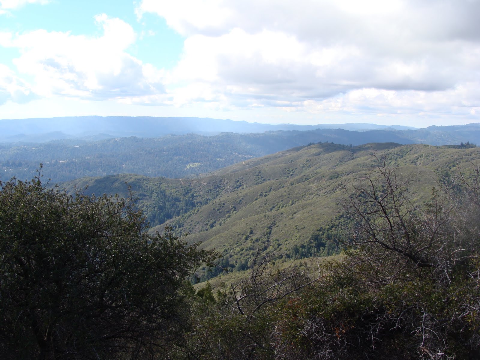 |
| Looking southwest from Umunhum. From front to back: Ralph's Mountain, the Summit Road ridge, and the rest of the Santa Cruz mountains |
When I started off on this ride I thought I might, if I felt particularly good, head from Umunhum to Loma Prieta, reversing an earlier ride. I did feel quite good, but on the way up my wife called to say that some tickets we bought a long time ago were (surprise!) for that evening. So I couldn't stay out indefinitely, nor could I return too zonked for a night out. So I decided just to explore this side of the road a little.
On the earlier ride I had taken the eastern trail, which looked good on a map but turned out to be an overgrown and almost impassable foot trail. This time I rode down the other ride, which is a fine, single-lane dirt road. It bends around for a few hundred feet and offers excellent views to the south, encompassing a snow-covered Loma Prieta and the bay. Eventually it comes into view of a mobile home. This road is marked as private, and having no need to tempt confrontation (or even inconvenience the residents), I turned right around.
 |
| The Loma Prieta ridge from Umunhum. Monterey Bay is barely visible in the background |
 |
| The weather radar dome and monolith on Umunhum, from the road on the way down |
Time to head downhill. I put the windbreaker back on and started down. The air, pleasantly cool until now, became piercingly cold as I gained speed and reduced effort. My ears were frozen, and I felt like I might get an ice cream headache.
A little way down, at the "no trespassing" signs, the same ranger who had passed me twice so far was parked, talking to a pair of riders and some hikers. I don't know what they were talking about, but one would guess it was something about not being allowed to go any further. Then here I come, riding out of The Forbidden Zone. Awkward. The ranger stopped me, asked me where I'd been, and explained the rules. Despite the signs that were terse, clear and numerous, I claimed to have misunderstood. He let me go with a smile. I'm not sure he could have written me a ticket, but in any case he was quite nice and could have been much more of a pain.
I rode back the way I came, which meant that it was downhill almost the entire way. Apart from dodging around a few cars that couldn't maintain the sort of speed I was carrying it was uneventful. In the end it was about 24 miles, with 3200 feet of climbing. The top was about 3300 feet, and I start at 250, so with a little intermediate climbing I think the Garmin may have shorted me. But it's been overestimating my climb recently, so it's only fair.


